|
q-store
|
DECLASSIFIED
APRIL 1977
|
|
|
Click for
sample detail
Revised
to include March 31, 1936 and Re-traced under the direction of
C.L. STURDEVANT
Lt. Colonel, Corps of Engineer
Department of Engineer
|

|
Click for
sample detail
Received
in compliance with cablegram 7772 - April 15, 1936
C of E. 061.2D-156
|
|
|
It has taken
us a few years to gather together a selection of maps, and to
have them copied. Either you can go to the National
Archives and look for them yourself, or you can purchase them
from us, and allow me to retire early. (As if!!)
|
|
|
.
The
"Buy now" buttons
are under construction
 |
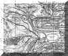
The 1936 map -
folded $20
Revised
to include March 31, 1936 and re-traced under the direction of
C.L. STURDEVANT, Lt. Colonel, Corps of Engineer, Department of Engineer.
The 1936 map is reproduced from a series of 25
A-4 size photocopies I obtained from a well-worn and
dog-eared version in the possession of the Corregidor
Foundation. We then stuck the photocopies together
and ran it through an architectural photocopier. The
original map was comprised of three sheets. Our 1936 map
has these three sheets photocopied together as one very
large map. The map is over five foot long and 33 inches
high and is posted 2nd class airmail, folded.
|
|
|
|
|
|
|
|
The 1936 map -
same as above, but rolled and posted in a
cylinder- $25 |
 |
|
|
|
|
|
|
1942 update map - $30
The 1936 Map was updated
in 1942. We have two of the three individual sheets,
which were finally declassified on *. The third sheet is
Sheet 3 of the 1936 map. The quality of the reproduction
of these two sheets is superior to our 1936 map, because
we have a first generation photocopy of the original map
as our 'original'.
|
|
|
|
|
|
|
|
1945 Jump Map -
$20
A photocopy of the map
issued to the 503d PRCT for the 16 February jump;
the original map was produced doublesided, with a
drawn map on one side and an aerial photomap on the
other. Reproduced here with both faces on on one side,
it now measures 38" x 22". The map sections
Corregidor into 1000' squares, and is marked
"SECRET", highlighting the strafing lines
which could not be crossed until 1030 hrs. Shockingly,
though better maps were available, a decision was made
to issue this map, clearly inadequate, for combat
use.
|
|
|
|
|
|
|
|
The 1936 Map + The 3
1942 Maps + The 1945 Jump Map - $60 |
|
|
|
|
|
|
|
Malinta Storage
System as of June 30, 1934 - $20
A photocopy of the map
prepared in the office of the Department Engineer Harbor
Defenses of Manila and Subic Bays, Ft. Mills,
"SECRET". Photocopy is a negative of an old
blueprint, so now is quite grey.
|
|
|
Join
PayPal and send internet secure payments by e-mail


|
|
|
Our mail address is:
CORREGIDOR HISTORIC SOCIETY
4 Jordan Tce
Bowen Hills
BrisbaneQ
AUSTRALIA 4006
|
|

