![]()
|
� 2003 Corregidor Historic Society - all rights reserved |
![]()
|
� 2003 Corregidor Historic Society - all rights reserved |
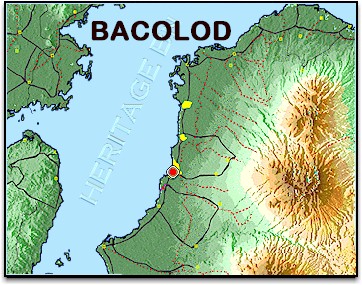
8 April 1945 � �We loaded on trucks early in the
morning and moved out on coastal highway, Highway #1, which went around the
northern end of the island. This was a good asphalt surfaced highway. Almost
all the Japs had retreated to the hills well before we landed. A few suicide
parties had been left. Pulapandan was about 60 miles from Fabrica, where the
large sawmill was located. After moving about 15 miles we came to the capitol,
Bacolod. This was a fair size city, by far the largest we had seen since
leaving Australia. We travelled on the flat coastal plains . . . and we could
see the mountains 10-12 miles inland and the plains gradually rising towards
them. Many large rivers had their origins in the foothills. There were a
number of large steel bridges spanning these rivers along the highway . . . We
passed through Silay which was a town of about 20,000 people . . . After
proceeding east on Highway #1 several more miles we turned off on a gravel
surfaced road and headed to�wards the mountains. We moved through the old sugar
cane fields several miles fording a broad, shallow river, the Imbang River and
stopped and detrucked at our first bivouac area . . . The road we were on was
Tokaido Road. This is shown on the Imbang River map as a railroad..�
Bill Calhoun, F Co.