|
"TRIUMPH IN THE
PHILIPPINES"
_________________
Robert Ross Smith

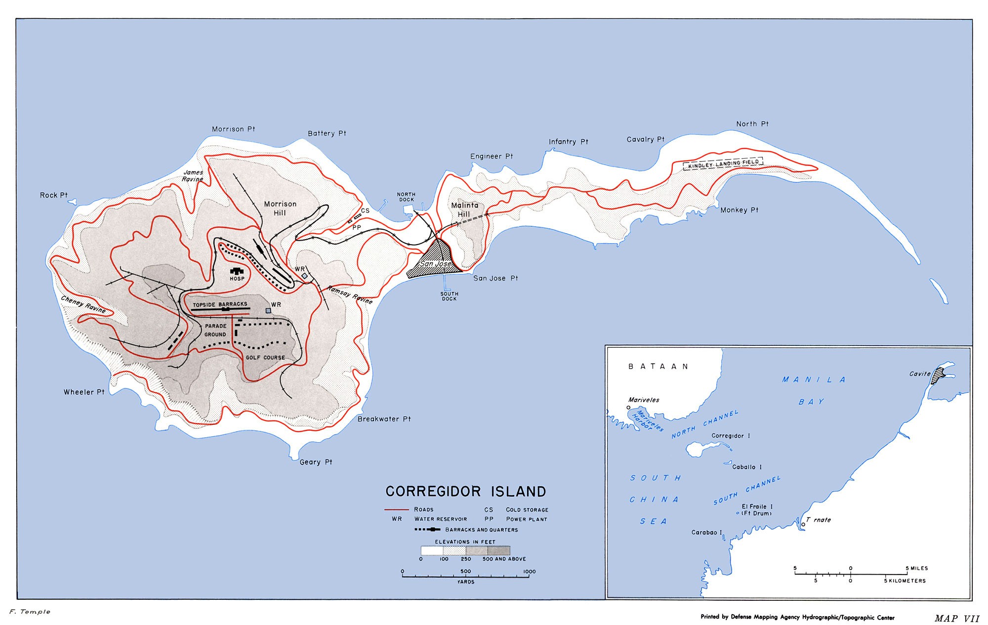
Map VII
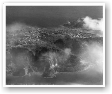
Corregidor Island
Landing Field B, Lighthouse, Water Tanks,
Senior Officer's Row, Batteries Geary & Crockett
Searchlight Point, No Name Point,
Btry Wheeler, Landing Fields A & B.
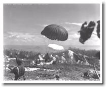
Landing Field B, Noon Drop, AA Tower,
Caballo Is. in the background.
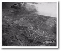
Battery Wheeler, NCO Married Qtrs., Landing Field A,
Topside, Smokescreen for amphibian landing.
PT Boat heading for stranded paratroopers - Searchlight Point (left).
A C-47 deposits a stick over Landing Field B. Mt. Mariveles and
Mt. Natib, Bataan in the background.
|
On 9 January 1945, the Sixth Army under the command of Lt. Gen. Walter
Krueger commenced the largest United States Army operation in the
Pacific. It entailed the use of more ground forces than did the
operations in North Africa, Italy, or southern France. Unlike previous
operations in the Pacific, the number of U.S. troops engaged, coupled
with the ability to maneuver these forces in the central plains north of
Manila, was more characteristic of European operations than any other
Pacific campaign. By the time the campaign officially closed on 15
August 1945, over sixteen American divisions, or their equivalents, were
committed to the liberation of the Philippines and the fulfillment of
MacArthur's promise.
The
logistics for the Philippine campaign, and the buildup of arms,
munitions, materiel and personnel for the intended invasion of Japan,
could not continue based on supply lines commencing across the beaches
in the Lingayen Gulf, or across the severely limited berthing facilities
at Subic Bay. Manila Bay, was one of the best deepwater ports in the
region, and the key to the supply of the campaign. At the mouth of
Manila Bay, as a cork is to a bottle, lay Corregidor.
That
it had been the scene of the most bitter defeat MacArthur had known was
certainly an irony, but revenge wasn't the raison d'etre
why
Corregidor needed to be retaken. Well, not for MacArthur, anyway.
To the men of the Rock Force, however, the recollection of the surrender
of Fortress Corregidor, and the shocking news of the fate of the
prisoners of that campaign, was still fresh. It would certainly
influence
how
the campaign would proceed.

Corregidor
The Plan of Assault
Four salient features marked the planning for
and the recapture of Corregidor Island. 1 First,
unlike the situation in 1941-42 when MacArthur's forces held the
island as a final fortress, Corregidor had no significant place
in Japanese plans for the defense of Luzon. Second, planning was
based upon intelligence estimates that reckoned the Japanese
garrison at less than one-sixth of its actual strength. Third,
the assault plan called for a parachute regiment to drop onto a
small, rough area ill suited to such an undertaking. Fourth, the
operation involved the most difficult of all modern military
maneuvers--a co-ordinated parachute and amphibious attack, which
had so far during the war met with only limited success.
Corregidor, logically the key to the defense
of Manila Bay, was important to forces occupying Luzon only if
the defenders elected to hold the strategically vital bay
region. Thus, when Yamashita turned to a static defense in his
mountain strongholds, the Japanese garrison on Corregidor became
an isolated outpost of no strategic significance to him.
Nevertheless, until the island was secured, the Japanese on
Corregidor could harass Allied shipping within Manila Bay and
could also use the island as a refuge for escapees from the
mainland. Even if all military reasons for the early seizure of
Corregidor could be brushed aside as of no moment, there still
remained the matter of sentiment. Many officers at GHQ SWPA
fervently awaited the recapture of "The Rock," and if it could
be done dramatically--by means of a parachute drop, for
instance--so much the better.
When MacArthur had outlined GHQ SWPA plans
for securing Manila Bay to General Krueger, he had told the
Sixth Army commander that those plans envisaged taking
Corregidor by parachute drop, by amphibious assault, or by both.
The final decision, the commander in chief went on, would await
the results of an intensive aerial bombardment. 2 Upon
receipt of this information on 3 February, the Sixth Army's G-3
Section quickly prepared a plan calling for the principal effort
to be an airborne assault by the separate 503d Parachute RCT
from Mindoro, where the regiment had been stationed since its
landing on 15 December. Krueger's planners also proposed a
nearly simultaneous and supporting shore-to-shore operation, to
be conducted by a reinforced battalion of the 34th Infantry,
24th Division, from Mariveles, Bataan. The date of the attack
was set for 16 February.
MacArthur approved the combined
parachute-amphibious plan on 5 February, 3 and
simultaneously canceled his proposal to await the results of air
bombardment--which had not yet begun in earnest--before deciding
upon a definite course of action. Indeed, the Sixth Army's plan
was prepared and approved so quickly as to suggest that planners
were so familiar with the concept of the dual assault on
Corregidor that only a bare hint was needed for a preconceived
plan to become a reality.4
The decision to employ paratroopers to make
the principal assault against an objective of Corregidor's size
and terrain merits attention. Shaped like a tadpole, with its
bulbous head pointing west toward the South China Sea,
Corregidor is but three and a half miles long and one and a half
miles across at its point of greatest width. (Map
VII) The eastern--tail--section is sandy, wooded, and gently
sloping, its highest point not much more than 150 feet above the
bay. Near the center of the island, tunneled Malinta Hill rises
abruptly to a height of some 350 feet, while immediately to the
west the ground falls away just as steeply to a 500-yard-wide
waist rising from sea level to a saddle about 100 feet high.
Known as Bottomside to the two generations of
American soldiers who garrisoned Corregidor before World War II,
the waist boasted small docks on both the north and the south
and was the site of the demolished barrio of San Jose.
Bottomside's sandy beaches provided good points for amphibious
assault. Equally good and wider beaches were to be found along
the tail section--it had been on the north shore of the tail
that the Japanese had made their main assault in 1942.
West of Bottomside lay a gradually rising
area known as Middleside, giving way on the west to steeper
slopes leading to Topside, as the central portion of the
tadpole's head was labeled. Covering a fairly even surface from
400 to 500 feet in height, Topside dropped precipitately to
Manila Bay on the north, west, and south. Other than the slopes
from Middleside, there were only two feasible approaches to
Topside: James Ravine on the north and Cheney Ravine on the
west, both easily defensible. Access to the western part of
Middleside and to Topside's eastern slopes could also be had at
Ramsay Ravine, at the southeast corner of the tadpole's head.
Topside is the key terrain feature on
Corregidor, and against a defense centered there conquest of the
island could be an extremely bloody affair. From Topside almost
all logical sites for amphibious attack can be brought under
fire, and even troops landing on the tail section, masked from
flat trajectory fire by Malinta Hill, would be exposed once they
tried to move past the hill toward Middleside and Topside.
Amphibious assault at any point could prove costly, as the
Japanese had learned in May 1942, when they had lost
approximately half their initial assault force. 5 |
|
  |
|
|

|
|
|